The Optimist, the student newspaper at Bloomington High School South, is raising money to help pay for its website. The service costs about $1,100 a year, and the paper hopes to raise enough to cover more than one year.
The yearly fee goes to School Newspapers Online. It covers the site, an app, tech support, and hundreds of journalism lessons written for teen news staffs. If local student journalism matters to you, a gift of any size helps.
115 years of student reporting
The Optimist has been South’s newspaper since 1911. Its student journalists publish news, features, sports and opinion online every day, and they print an edition once per trimester. With print that infrequent, the website is where most of their work reaches readers.
Recent stories include the marching band’s regional win, three South students named Lilly Community Foundation Scholarship finalists, and whether high caffeine is healthy for teens. We also carry The Optimist’s headlines on our Bloomington news hub, alongside other local outlets.
The paper is part of local history too. The Monroe County History Center keeps issues dating back to 1923 in its research library.
Your donation goes to The Optimist, not to Bloomington Online. We are sharing this because student journalists are part of how our community stays informed.
Two days ago there was no 3D Bloomington. Now there’s one you can fly around, from the copper fish on the courthouse to the sailboats on Lake Monroe. It’s built from real survey data, it lights up at dusk, it changes with the seasons, and every business in our directory can show up on it. Here’s what we built, where the data came from, and how it came together.
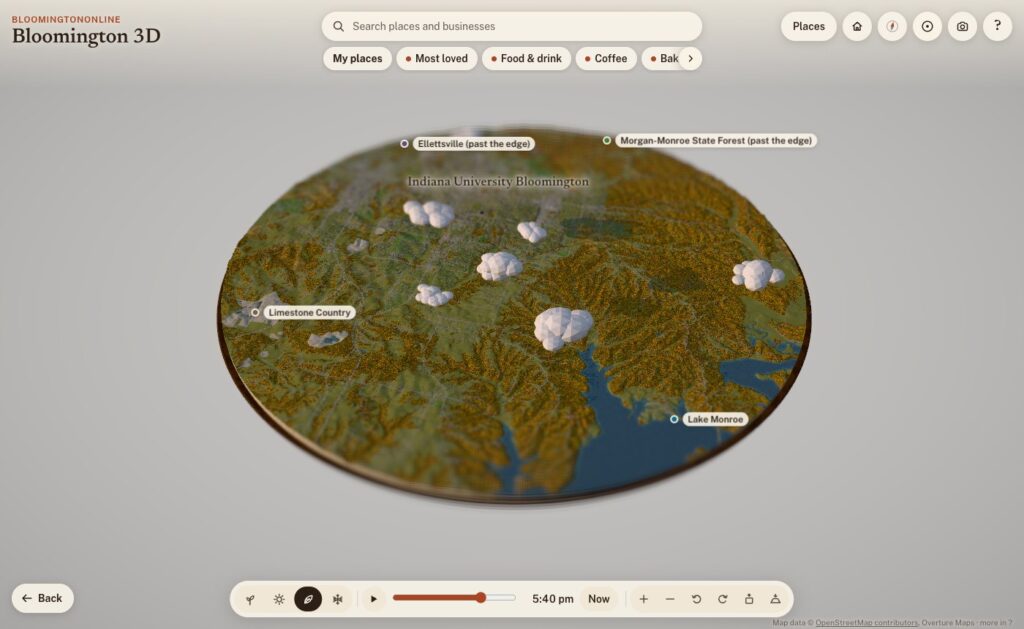
The whole board: Bloomington and the hills around it, about 12 miles across, on a fall evening.
What it is
Bloomington 3D is a model of Bloomington and the country around it: a round board about 19 kilometers (12 miles) across, centered just south of downtown, sitting on a walnut plinth like a museum diorama. The cut edge shows layers of limestone, and where the board slices through Lake Monroe you can see the water in cross-section.
It runs in any modern browser, on a phone or a computer, with nothing to install. It opens on the Courthouse Square. Drag to move, pinch or scroll to zoom, and tap anything outlined, pinned or named to read about it. Each place has a card with a short, fact-checked write-up, nearby places to wander to next, and a link you can share. For example, bloomingtononline.com/town/#griffy opens straight onto Griffy Lake.
Where the town comes from
None of the geography is drawn by hand. Every street, building, tree and creek comes from public data, and the map credits each source on screen. Here’s what’s in it.
Streets, buildings and paths: OpenStreetMap
The base layer is OpenStreetMap, the volunteer-built map of the world. It supplies the roads, the B-Line and the other trails, the creeks, parks, rail lines and building footprints. It also has the small things you notice once you zoom in: about 2,900 sidewalk segments and 4,300 other footpaths, crosswalks, bike lanes, benches, bike racks, picnic tables and parking lots, which fill up with little parked cars.
The hills: USGS elevation data
Southern Indiana isn’t flat, and the model shouldn’t be either. The terrain comes from USGS elevation data via open terrain tiles, with the hills exaggerated about two times so the ridges and hollows read at a glance, the way a museum diorama does. Buildings and trees stand at their real heights. Where OpenStreetMap doesn’t map the woods, the model fills undeveloped slopes with forest, because that’s what our hollows are.
Real building heights: 154 million laser points
This is the part I’m proudest of. Indiana was flown with lidar between 2017 and 2019 for the USGS 3D Elevation Program: an airplane sweeps a laser across the ground and records where every pulse bounces back. We streamed the 21 tiles that cover downtown, campus, Prospect Hill, Elm Heights, Bryan Park and the near west side, which is 154.6 million points, and turned them into a one-meter grid of the town.
From that grid, the model measures:
the eave and ridge height of 11,565 buildings, so roofs are the right height and the right shape
stepped roofs on bigger buildings, traced in tiers every 3.5 meters, so a building with a tall section and a low wing looks like that
towers that rise above the rest of a building
the tree canopy, so the woods and big yard trees stand where they really are
the bare ground under it all, more detailed than the terrain everywhere else
Outside that core, building heights come from Microsoft’s machine-learning estimates, published through Overture Maps, which also fills in buildings OpenStreetMap doesn’t have yet. All told, there are about 35,000 buildings on the board.
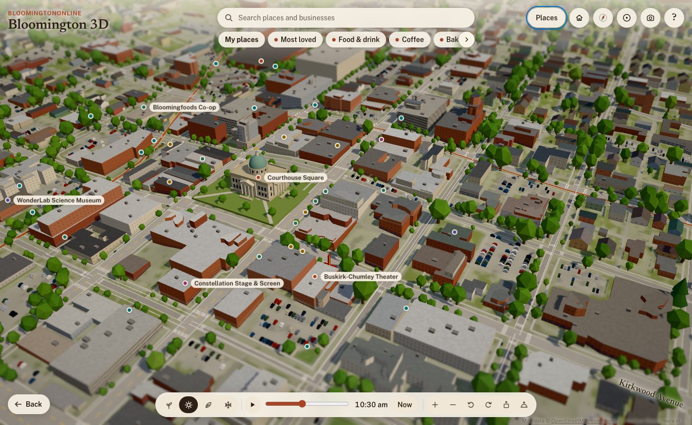
Downtown on a summer morning. Building heights and roof shapes are measured from lidar; roof colors come from the 2025 aerial photos.
Roof colors: the 2025 aerial photos
Flying over a model where every roof is the same gray is boring, and it isn’t Bloomington. So for 11,518 roofs in the core, the model samples the real color from IndianaMap’s 2025 statewide aerial imagery: the red metal roofs, the white flat roofs on campus, the weathered shingles. The same photos also lighten the ground where there’s paving and green it where there’s grass. We use the photos as data, not as a texture, so everything stays in the model’s diorama style.
36,000 real trees, and fall colors by species
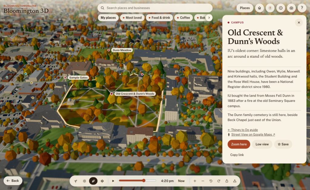
The City of Bloomington keeps an inventory of its street and park trees, and IU surveyed its campus trees in 2019. Together that’s about 36,000 trees on the board, each standing where it really stands, and each with its species. So in fall:
red maples, sweetgums and red oaks turn red
sugar maples turn orange
tulip trees, ginkgos, honeylocusts and redbuds turn yellow
white oaks, beeches and sycamores go bronze
pines, spruces and cedars stay green
In spring, the redbuds and crabapples bloom pink and the dogwoods and pears bloom white. Dunn’s Woods and the campus look different from the near west side because they’re planted differently, and the model knows it. Beyond the inventories, trees follow the lidar canopy in the core and the landcover everywhere else.
The Old Crescent and Dunn's Woods in fall. Campus trees come from IU's tree inventory and change color by species.
The city’s own maps
From the City of Bloomington’s open data we use:
Historic districts and neighborhood boundaries: outlines like Prospect Hill and Elm Heights are the city’s own.
The bikeways layer.
The historic buildings survey: houses it rates as historic get an older-house look in Elm Heights and Prospect Hill.
The public art inventory: 42 outdoor works, each with the city’s photo, artist, year and medium. A “Public art” walk visits them in order, starting at the Square.
And BloomingtonOnline itself
Our own content is on the map too:
Things to Do guide: 67 places, linked both ways.
Neighborhoods guide: the north, east, south and west sides of town.
The business directory: more on that below.
Light, time and the seasons
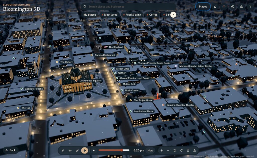
By default the model runs on live Bloomington time. The sun is where the real sun is, calculated for our latitude down to the minute, daylight saving time included. Watch it long enough and the shadows swing across the Square, the sky warms at golden hour, the street lamps come on, and the windows downtown light up after dark.
Live mode also follows the calendar, and the four season buttons let you jump ahead:
Spring: the redbuds and dogwoods bloom.
Summer: sailboats on Lake Monroe, paddlers on Griffy, and fireflies at dusk.
Fall: the species colors, with leaves drifting down.
Winter: snow on the roofs, wet streets and moonlit fields.
Some details only show up at the right moment. The farmers’ market tents are on Showers Common on Saturday mornings from April through October. From the Friday after Thanksgiving through December, the Canopy of Lights glows over the Square at night.
The Canopy of Lights over the Square, shown from the Friday after Thanksgiving through December.
You can also link to a moment. Adding ?season=winter&time=18:30#square to the address opens on the Canopy of Lights at dusk, which is handy for stories.
Hand-built landmarks
Data gets you most of the way. A few places deserved to be modeled by hand:
The courthouse: its dome and windowed drum, the copper fish weathervane, and window rows that light up at night.
Campus: the Sample Gates, the Rose Well House, Kirkwood Observatory’s dome, Showalter Fountain, the IU Auditorium’s front and the field at Memorial Stadium.
Downtown: the Buskirk-Chumley’s marquee and the sawtooth roof of the old Showers plant, now City Hall.
The Little 500 track.
Grout piles: heaps of waste limestone blocks along the rims of the quarries.
Older brick blocks within a few minutes’ walk of the Square get storefronts, awnings, arched upper windows and limestone cornices.
Ways to explore
A first look: a guided tour of the highlights.
Fly-alongs: rides along the B-Line, Kirkwood and out to Clear Creek. Nine more stay low: on foot down Fourth Street, College Avenue, Walnut, Third Street and 10th Street through campus, and by bike along the 7-Line, Cascades, Jackson Creek and the Karst Farm Greenway. The low routes were checked against the lidar so the camera clears every roof and treetop.
Low view: drops you to about 10 meters, looking down the street toward the horizon. Smaller places link to Google Street View when you want the real photos.
Circling: pick a place and the view slowly circles it, like Google Earth after a search.
Home, Back and the compass: Home takes you back to the Square, Back to your last view, and the compass to north, then straight down.
Save a picture: the camera button saves the current view as an image, credit included.
The business directory, on the map
This is where the model stops being a pretty picture and becomes part of BloomingtonOnline:
Every business on its building. More than 1,900 directory listings now have a See it on the 3D map button. The model places each one on its actual building, matched by name and address against OpenStreetMap and Overture, instead of rough estimates from street address ranges. Businesses just past the edge of the board get a pin on the rim pointing their way.
Categories as layers. The chips under the search box show one kind of business at a time: Food & drink, Coffee, Bakeries, Bars & nightlife, Pizza, Shops, Arts & entertainment, and Fitness & recreation. More has every directory category. Category pages in the directory link to their view on the map, so coffee is one tap away.
Search the whole directory. Type a name and any business on the board comes up.
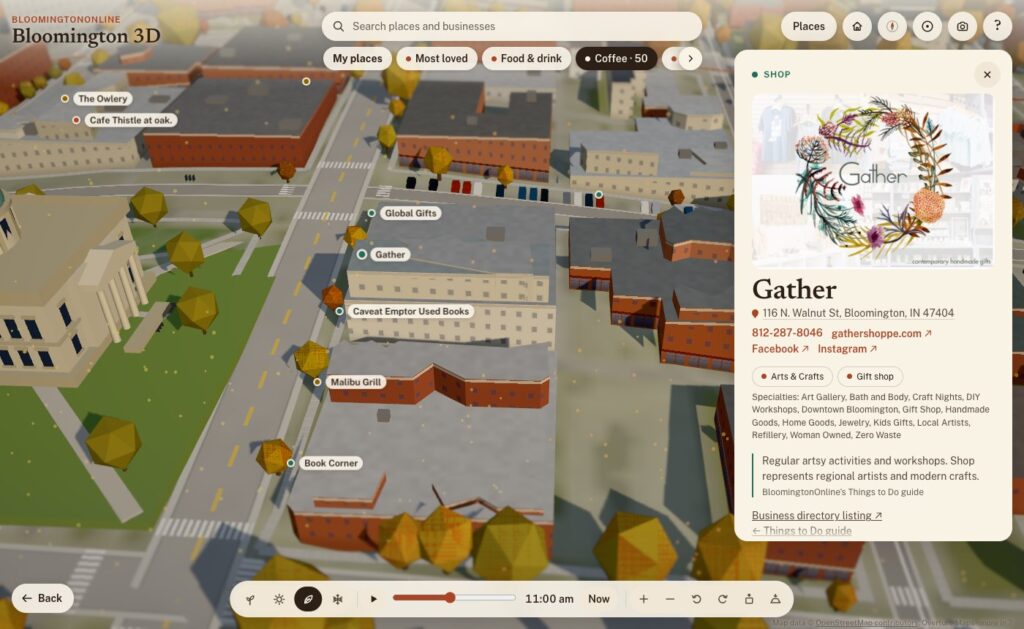
Rich business cards. Each card has the business’s photo, its categories and specialties, the address (linked to Google Maps), tap-to-call phone, website and social links. A Flag this listing link reaches our correction form.
My places. Tap Save on any place or business, here or on its directory page, and it goes into your own list on the map. You can share the whole list with a link.
Locals love this. A heart on every business. Votes add up, and Most loved shows the favorites on the map.
With the Coffee layer on, every coffee shop is a pin. Gather's card shows its photo, address, phone, website, social links and categories, live from the directory.
Putting the directory on a map also showed us where the directory needed work. Over the years, several bulk imports had added some businesses two or three times. So we built a review page, went through every suspected duplicate, and merged 194 duplicate listings into the right ones. Nothing was lost: phone numbers, photos, categories and tags were combined, and every old address now redirects to the listing that stayed. The directory now warns us when a new listing looks like one we already have.
How it was built
I built Bloomington 3D with Claude Code, Anthropic’s AI coding agent, working as a two-person team: I set the direction, judged the results and knew the town, and Claude wrote the code, chased down the data and tested everything before it went live. Every feature went through the same loop:
Ask. I’d describe what I wanted in plain words: “add Third Street too”, “the category selectors are being cut off”, “let’s make a camera icon for saving the view”.
Build. Claude found the right data or wrote the code, often several pieces at once.
Test. Every change was checked in a real browser, on desktop and phone sizes, before it shipped. That included flying the camera down the new fly-alongs and clicking through the new buttons.
Ship. A one-command deploy publishes the new version to the site, keeping the old one for an instant rollback, and every change is saved in version control. As of this writing there are 146 of them.
A few principles held the whole way through:
Facts first. Every claim on a place card traces back to a source on a fact sheet, and the copy was fact-checked twice. If something couldn’t be verified, it stayed out. That’s why the cards don’t say why the courthouse has a fish: nobody knows for sure.
Open data, credited. Every source is credited on the map. There’s no paid mapping service, no API key, and no recurring cost.
Private by default. Update, Oct 14: the map now uses anonymous Google Analytics to count what people tap, search for and share, so we can fix what is confusing. It collects no names or email addresses, and your saved places still stay on your own device. Tapping the heart on a business also runs a quick background check from Cloudflare (the same one our contact form uses). Your saved places stay on your own device.
Works on a phone. The model picks a lighter quality level on phones, runs slower when nothing’s moving to save battery, and offers lighter graphics if things get choppy. It scores 100 for accessibility on Google’s Lighthouse test.
Two days, start to now
Day one (Sunday).
Early afternoon: the first version, OpenStreetMap streets and buildings on terrain, with a tilt-shift look that makes it feel like a miniature.
Next two hours: three art-direction passes, then night lighting, seasons, the guided tour, landmarks, boats, storefronts and performance tuning for phones.
About 3 p.m.: it went live on the site.
Next hour: the lidar heights, roof colors, real trees, city outlines, public art and the first directory integration.
Evening: the Things to Do guide, the low fly-alongs, circling, directory pins on their buildings and category layers. It also got its name. It had started life as “Bloomington in miniature”, which I didn’t love.
Finding things: the search bar with category chips, and friendlier controls (Home, Back, double-tap to zoom, first-visit tips).
Links and history: working browser Back and Forward, and shareable links that stay tidy.
Directory features: richer business cards, My places, Locals love this, and pins for businesses just past the edge.
Directory cleanup: the duplicate merge.
A lot of the best changes came from simply using it. On day one I noticed the business pins weren’t quite on their buildings. The directory’s locations were estimates from street address ranges, often 20 to 100 meters off, so we matched every listing to its actual building instead. Coming in from a directory listing, I noticed the address bar kept the old business’s name. The browser’s Back button didn’t walk back through places. The category chips were cut off on a phone. Each of those took minutes to fix once I’d noticed it.
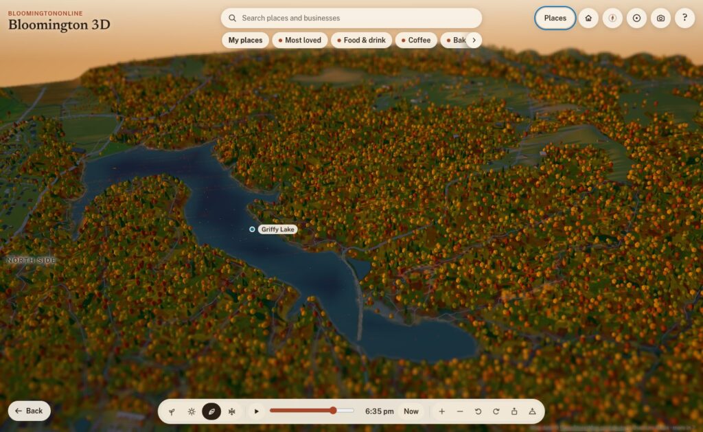
Griffy Lake at sunset in fall.
Where it goes from here
After two days, Bloomington 3D includes:
about 35,000 buildings and 36,000 real trees
50 written-up places, 67 Things to Do and 42 works of public art
a dozen fly-alongs
more than 1,900 businesses
four seasons and a sun that keeps real time
It’s also a living thing, and that’s the exciting part. A few ideas on the list:
a “show where I am” button
events on the map
live weather
more guided tours drawn from our guides
your saved places following you from device to device
But the best next steps will come from you. Take it for a spin, find your street, and save your favorite spots. Then tell us what you’d like to see, what’s missing, or what we got wrong. If a business is on the wrong building or out of date, use Flag this listing on its card. We read every one.
A confirmed tornado touched down in Bloomington, Indiana on the night of February 19, 2026, carving a path of destruction across the west side of the city and into residential neighborhoods including Fieldstone and Stonechase. No fatalities have been reported, but property damage is extensive.
The storm moved through with sustained winds exceeding 60 miles per hour. In the Fieldstone neighborhood, entire roofs were lifted from homes, gutters and siding were stripped, trees were damaged, and outdoor furniture was scattered across yards. Debris was reported throughout the area, and the damage extended well beyond individual streets.
This reporter and family are among those affected. While our family is safe, we sustained roof and gutter damage, a downed backyard tree, and lost outdoor furniture. Our neighbor’s home was among the hardest hit on our street, with their roof completely gone and garage door destroyed.
A neighbor’s home in Bloomington’s Fieldstone neighborhood shows the aftermath of a tornado that struck the west side of the city on the night of February 19, 2026. The roof is missing and the garage door was completely destroyed. Photo: Dave Martin / BloomingtonOnline.com
Fifth Third Bank and Commercial Damage
Among the most visually dramatic damage was to the Fifth Third Bank branch off Third Street near I-69, where the roof was entirely stripped from the building, exposing the structural framing. The drive-through canopy was heavily damaged and debris was scattered across the parking lot. Storm Track 8 Meteorologist Drew Narsutis, reporting from Bloomington, confirmed the bank as one of the hardest-hit commercial structures from the evening’s storm.
The Monroe County Humane Association (MCHA) campus also took a direct hit. In a statement released overnight, Executive Director Andrew Krebbs confirmed significant structural damage to the facility and the total loss of a storage building containing the organization’s food and supply inventory. All animals were safely evacuated and relocated to trusted care partners including Animal Care and Control and The Ranch Cat Rescue.
“To the community, we’ll need you once we assess next steps. Please avoid our campus for now, as it’s unlikely usable in the near future.”— Andrew Krebbs, Executive Director, Monroe County Humane Association
Krebbs also thanked Shane and Scott from Electrical Services, Police Chief Diekhoff and the Bloomington Police Department for helping secure medical supplies, and the many community members who reached out overnight.
⚠️ Please avoid the MCHA campus. If you have an upcoming appointment, MCHA will contact you proactively in the coming days. Physical donations cannot be accepted at this time — follow their official Facebook page for updates on how to help.
Stonechase Neighborhood Near the Airport
The Stonechase neighborhood, located near the Monroe County Airport, also sustained significant damage. Reports from residents and storm spotters describe windows blown in, walls cracked, siding stripped, and interior debris. Meteorologist Todd Klaassen noted the damage was consistent with the radar rotation he had been tracking as the storm moved through.
Unconfirmed reports from community members describe significant damage at the Monroe County Airport, including hangar doors blown completely off, aircraft dragged across the tarmac, and private jets and vintage vehicles reportedly destroyed or overturned.
Lightning Over Rose Hill Cemetery
The Bloomingtonian captured dramatic images of lightning streaking across the sky over Rose Hill Cemetery as severe storms moved through the area, underscoring the intensity of the weather system that preceded and accompanied the tornado. 📷 See the photo on Facebook
Community Response
As word spread overnight, Bloomington’s community response mobilized quickly. Volunteers, licensed electricians, animal care workers, and organizations from as far as Indianapolis and Lafayette offered assistance. Stephanie Miller offered a large building as a potential temporary shelter for MCHA animals. Hal E. Kae indicated a volunteer team from Indianapolis-based PAAW could be deployed.
The outpouring reflects what Bloomington does best — showing up for neighbors when it matters most.
What to Do Now
If your property was damaged, document everything thoroughly with photos and video before cleanup begins, and contact your insurance provider as soon as possible. Monroe County Emergency Management is the primary point of contact for disaster assistance resources. Avoid damaged structures, downed power lines, and debris-filled roads until they are cleared and assessed.
BloomingtonOnline.com will continue updating this story as more information becomes available. If you have photos, video, or damage reports to share, contact us directly.
Media credits: Original video and photography by Dave Martin / BloomingtonOnline.com. Please share original posts directly where possible.
Sources: MCHA Executive Director Andrew Krebbs (official statement), Storm Track 8 / WISH-TV Meteorologist Drew Narsutis, Meteorologist Todd Klaassen, The Bloomingtonian, community reports via Facebook.
Monroe County has just taken a major step toward preserving natural beauty for future generations—thanks to a remarkable donation from the trust of Nancy Huntington, 409 acres on the southeast side of Bloomington will become the site of a brand-new county park.
📍 The land sits near E Moores Pike, S Smith Rd, and SR-446, and will be protected for recreational and nature-based uses only—no non-recreational development will be allowed.
County leaders say plans are still in the works, but trails for hiking, walking, and biking are already envisioned, along with a deep commitment to protecting the site’s ecological value in the Monroe Lake basin.
🗣️ What Local Leaders Are Saying
“Not often do we have this historic opportunity to ensure over 400 acres are set aside from development to be cherished by future generations,” — Julie Thomas, President, Monroe County Board of Commissioners
“This park represents a commitment to the history, people, and natural environment of Monroe County,” — Julie Thomas
“This natural area will provide significant benefits to nearby residents and families while continuing the county’s commitment to environmental stewardship,” — Commissioner Lee Jones
“Monroe County is once again showing federal and state leaders what responsible governing looks like.” — Commissioner Jody Madeira
🌿 Why It Matters
At a time when state and federal park systems are facing budget cuts and staffing reductions, this move sends a powerful local message: 🛠 Invest in access. Protect green space. Plan for the future.
This land won’t just be a place to play—it’s a symbol of environmental stewardship, community wellness, and generational foresight.
📫 For more information, contact: Kelli Witmer, Director, Monroe County Parks and Recreation 📧 kwitmer@co.monroe.in.us
We use cookies to see which pages are useful (Google Analytics, Microsoft Clarity). No ads, and nothing is sold. Privacy policy